Sunday, 29 March 2015

The Future of Open Building

The Future of Open Building

An Explanation Of The Concept

A street analysis of Commercial Street, Fordsburg and redesigning the street edge
with relevance to the Open Building concept. 
© Diana Wolny, 2015
When referring to the notion of Open Building, John Habraken argues that the system should mediate between the needs of the individual as well as the community that inhabit the space. This allows for the design of a building or space with different systems that have the potential to be personalised and altered according to the individual’s or community’s needs at neighbourhood level. These conditions offer a sense of ownership, responsibility and care to those inhabitants, therefore creating an opportunity for a safer and cleaner space for them to occupy.

This is achieved through gathering communication and information, mainly on-site, in order to generate an infrastructure that evaluates what is required for the people within that particular neighbourhood. Through this understanding, one can develop an infrastructure that identifies the urban hardware and urban software within a neighbourhood and how it influences its users. Without the individual, the space would become inflexible and standardised and could therefore have a greater potential of failure due to the fact that the needs of the individual or community could not be met.

The relevance of Open Building is important to the individuals within a neighbourhood as it unites levels of decision making with construction as well as control within the system. These levels include the town fabric (the tissue), the base building (the support), and fit-out (the building’s infill). The buildings and infill within a neighbourhood can be transformed and replaced while the town fabric still remains the same.

This system provides the infrastructure the opportunity to reuse its building parts in order to lengthen its life expectancy and thus prevents the accumulation of waste materials which leads to a better design of an infrastructure. The director of OBOM Research Group, Ype Cuperus, states that Open Building is “a multi-facetted concept, with technical, organizational and financial solutions for a built environment that can adapt to changing needs. It supports user participation, industrialization and restructuring of the building process”.

Sunday, 22 March 2015

Explorations In Urban Design & Architecture Individual Work Assignment

 Explorations In Urban Design & Architecture

Multi-Layered, Mixed Neighbourhoods In Newtown, Johannesburg

Mint Road, Fordsburg
Following our group urban design framework proposal, we were required to choose a site responding to our group analysis. Our design had to respond to the context into which it was inserted as well as relate back to the Open Building concept. It needed to cater for the diverse needs within the area, a selection of occupancy options and affordability levels.

The main intention of Group A's urban design framework was to link Fordsburg Square to Oriental Plaza via Commercial Road and transform it into a fully pedestrianized walkway. This was the site I was going to focus on upgrading for the community of Fordsburg.

The History Of Fordsburg Square & Oriental Plaza

Artist's impression of the events that formed Fordsburg Square and Oriental Plaza  © Diana Wolny 2015
From January until 14 March 1922, there was a strike against the gold miners and their employers due to a wage cut per shift for the black miners and retrenching the higher paid white miners for more affordable black miners. The strike became an open uprising where the South African Army as well as the Air Force were called in to bombard Fordsburg Square. These miners dug out large trenches next to the municipal toilet on Mint Road, a building that sheltered them from the army and would later become a heritage building to commemorate this day. The South African Air Force were informed to bomb the square from above but hit the nearby Presbyterian Church on Mint Road, which is now also a heritage building within the area. This day became known as the Rand Rebellion or Rand Revolt.

Today, Fordsburg Square is one of the main areas of Indian culture in South Africa and is an extremely colourful and lively meeting place for the community as well as its visitors.

Fietas was a flourishing community consisting of the Indian, White, coloured and Malay population before the 1970's. It was made up of two suburbs, being Pageview and Vrededorp, and in the late 1970's most of the community was forcefully relocated to other suburbs during apartheid under the Group Areas Act. While bulldozers broke down existing homes and the resident's belongings were thrown onto the streets, some people of the community stayed within the area in informal settlements while the majority vacated the area to places such as Lenasia and Eldorado park while the Indian traders regrouped in the space now known as Oriental Plaza.

Today Oriental Plaza is a successful tenant-owned shopping mall where people from all over South Africa come and do their shopping mainly over the weekends. The shop owners provide their customers with a unique shopping experience with great deals in what ever they are selling and is definitely the major attraction within Fordsburg.

My Concept

The Intention of my conceptual design was to allow pedestrians to have an enjoyable and exciting journey between two historical landmarks within Fordsburg.


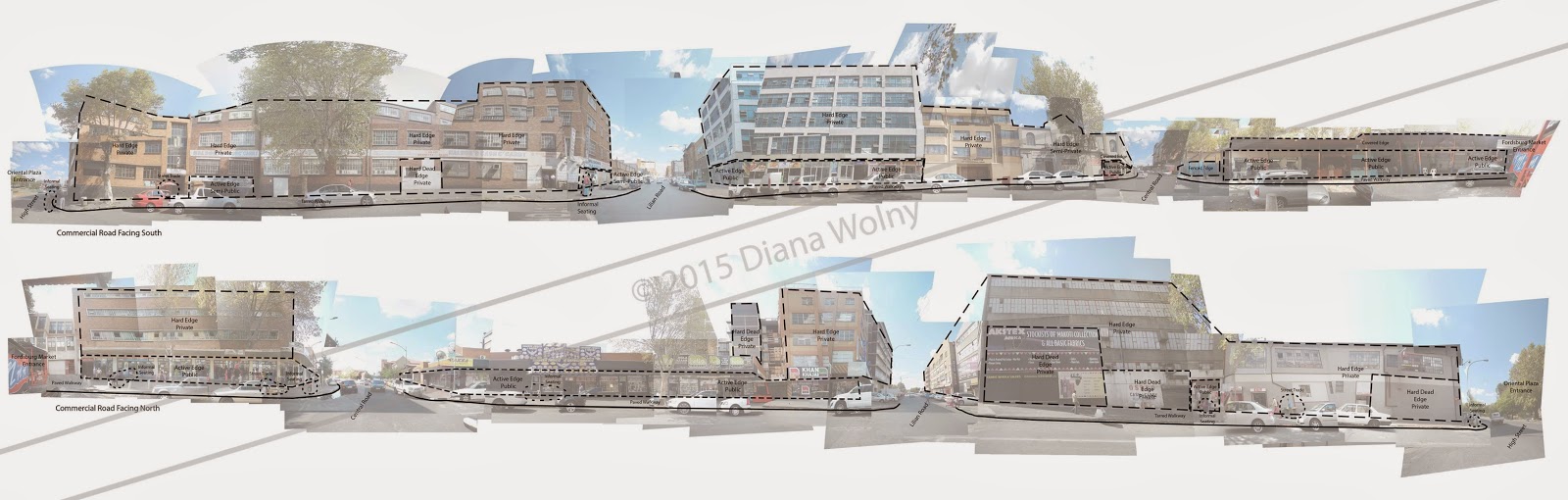
I began analyzing Commercial Road by marking out the active retail edges, hard and dead edges as well as informal seating and street trade activities. I noticed that the street traders along this edge did not have a specially allocated area for them to operate their business and were also open to the natural elements. 
After defining the areas mentioned above, I then began designing a sheltered space for the street traders that also responded to the active retail edges as well as giving the opportunity to create active edges along the hard and dead edges, not only on the ground level but also at the first level of some buildings. 


I noticed that the restaurants and cafeterias along Mint Road and Central Road did not have formal outside seating for their customers and discovered that this was due to the by-laws within those roads. Due to this observation, i wanted to further activate the edges on Commercial Road by adding outdoor spaces for the public to utilize for whatever their needs would be for that time therefore relating back to the Open Building concept.

I allocated areas for outside seating, sheltered street trade and gave the public a green roof to sit on and enjoy the view points towards Oriental Plaza and Fordsburg Square, further linking the two historical landmarks together. A paved area and water fountain area were also added for the public focusing more towards the children occupying the space, giving them areas to play sports as well as a water play area open to the elements.

I also added more trees within this corridor to aid the public in finding their way easier towards each node when approaching the area off Mint Road, Central Road, Lilian Road and High Street. After this exercise, I began cutting away at buildings on the ground and first floors, added volumes above existing one to two-storey buildings and pushing certain building edges out to create an interesting space for the public to move through down this corridor. I opened up part of Fordsburg Square again to commemorate its sole purpose and enhanced the public and green space in that node with the addition of a fountain area in the middle. I moved these traders down Commercial Road to further upgrade the hard and dead edges within the existing road.

I gave the potential for the public to access possible trading spaces on the first floor of certain buildings from the view points in my structure to further deal with the relationship of the lower and higher levels within the corridor.


Final Presentation

Fordsburg mapping analysis with the history behind Fordsburg Square and Oriental Plaza

Street analysis with concept sketches

Plan of potential activities on Commercial Road

Section through portion of Commercial Road, Fordsburg

Cross section through Commercial Road with precedent studies


Saturday, 21 March 2015

Explorations In Urban Design & Architecture Group Work Assignment

 Explorations In Urban Design & Architecture

Multi-Layered, Mixed Neighbourhoods In Newtown, Johannesburg


Overview

The MTech unit went to document information in the Newtown and Fordsburg districts. The class was split into four groups in order to do an in-depth analysis within these four sites and were then asked to compile an urban design framework based on our findings.

As a class, we marked out key nodes within our areas and then discussed how we were going to link them all within our overall urban design framework. 

Overall Urban Design Framework
Overall group presentation
Site model for presentation
After this task, we then moved onto our group urban design frameworks and began altering our areas based on our findings to come up with a development proposal that also responded to our overall scheme. I was part of Group A which focused on Fordsburg and our key nodes were Fordsburg Square and Oriental Plaza.

Mapping of heritage sites as well as analysis of street and building edges

Mapping of types of movement and activities as well as street section analysis through the site
Group A: UDF proposal
New building, green space and parking allocations in Fordsburg

New building allocations above and near existing buildings.
View from Oriental Plaza entrance looking towards Commercial Road


Friday, 20 February 2015

People, Systems and Infrastructure: Part 3

Let There Be Light

GERSH, A. (2011) FRONTLINE: BLACKOUT POWERLINES AT SUNRISE [Online] Available from: http://gershpost.com/?attachment_id=210.[Accessed: 20th February 2015].
One of the current main issues that South Africans face today is the problem of load shedding. This is caused by the poor conditions of the Eskom infrastrusture as reported by the ENCA (2015).

Due to the on-going electrical supply interruptions throughout the country, it leaves buildings and streets unlit and sinister; waiting for something to happen in the shadows. In my concept I want to address this crisis on a small scale by illuminating the darkened streets in Jeppestown with the use of stored energy. A model which introduces alternative means of electrical light application that doesn't rely on the city's electrical power supply. All forms of electrical features producing light in my design concept will be powered by a solar power system using photo voltaic cells.
An illustration of materials that might be used in my concept as well as solutions to Load Shedding on the streets.

On A Rainy Day

PAVEGEN. (2014) Technology [Online] Available from: http://www.pavegen.com/technology. [Accessed: 20th February 2015].
Another setback in the design is how to cater for days where there is insufficient sunlight to power these artificially lit corridors at night. The solution is harvesting kinetic energy into electrical energy from an individual's footsteps and store that energy for later use. This invention has already been put into use overseas and is seen as the way forward in green technology as stated by Pavegen CEO, Laurence Kemball, at the TedxRio Talk in Rio de Janeiro, Brazil (2013). 

Follow the link below to watch the presentation held at TedxRio:

Follow the link below to read up more on the Pavegen product:

Follow the link below to watch a short presentation on how the product's battery management system:

Interactive Elements

BRONWELL, B. (2009) Lightfader [Online] Available from: http://transmaterial.net/lightfader/. [Accessed: 20th February 2015].

In my design, I want to incorporate interactive elements using artificial light in order to draw the public into a social, relaxing and enjoyable environment outdoors. 

Apart from introducing the Pavegen product onto the pavement's facade, there will be an equivalent weight distribution product but in the form of electrical light. This interactive feature possesses semi-transparent photo voltaic cells so that LED light can be transmitted from underneath the system and will leave an eye-catching trail behind the individual using it.

ARTLAB. (2012) Water Light Graffiti, created by Antonin Fourneau in the Artlab [Online] Available from: http://www.digitalarti.com/wlg. [Accessed: 20th February 2015].

Another interactive feature will be placed on the walls within the concept design using LED lights that are activated using any damp surface. The intention of this element is to give individuals a space where they can be creative without the notion of permanently vandalizing a space. In relation to the Jeppestown site, this interactive facade's intent is to celebrate the existing graffiti artwork that is exhibited in and around the neighbourhood. Antonio Fourneau's Water Light Graffiti project was held in a public space in France and produced an incredible result of artwork styles. He constructed a sheet with thousands of LED lights which lit up every time a person came into contact with it with damp hands or with water, from a paintbrush or sponge to throwing a bucket of water over the panel (ARTLAB, 2012). 


Follow the link below to watch a short film about the Water Light Graffiti product:
https://vimeo.com/47095462


ILLUMIN. (2015) Volume IX Issue IV [Online] Available from: http://illumin.usc.edu/165/motion-sensors/. [Accessed: 20th February 2015].
Motion LED light sensors will also be installed into the street lamps for further energy efficiency. The sensor will be placed on the previous street light so that the pathway will be illuminated ahead of its user, increasing the sense of security within that corridor.

Conceptual Design Sketches


Final Concept

The aim of this pathway is to connect different nodes within a neighbourhood in order to invite the community as well as visitors at a social public level. This design could be implemented not only in Jeppestown but also at a global scale. By creating these pathway corridors, it will potentially upgrade the infrastructure and lifestyle around these corridors as seen in the precedent studies in my earlier blog post.


Thursday, 19 February 2015

People, Systems and Infrastructure: Part 2

Fear of Crime Following Urban Decay


BESTER, D. (2014) Johannesburg-Urban-Decay-Danie-Bester_2150 [Online] Available from: http://daniebester.co.za/new-project-johannesburg-beautifully-ran-down/johannesburg-urban-decay-danie-bester_2150/[Accessed: 18th February 2015].

It is evident that urban decay exists in Johannesburg, specifically in the Johannesburg Central Business District and its neighbouring areas. This is due to the fact that after the Group Areas Act was abolished in the 1990’s, many people who were in the inferior classes during apartheid were now able to relocate to the designated "white" areas which made many corporate businesses, including the stock exchange, move their investments to other suburban areas such as the Sandton Central Business District. 

BLOGGER, (2012) Ponte Today [Online] Available from: http://www.yourplace.co.za/africa/ponte-today/[Accessed: 18th February 2015].
Many buildings were left vacant especially in Hillbrow, which is seen as one of the "most densely populated neighbourhood(s) in South Africa" (Johannesburg Development Agency, 2009). This allowed the lower income groups as well as numerous African immigrants to come inhabit the spaces legally and illegally resulting in poor upkeep and the dilapidation of buildings and leading towards the degradation of the area itself. Once this was underway, slowly crime as well as violent acts started taking place within and around these regions which led to people being afraid of their own safety and locking themselves up in their own homes (Johannesburg Development Agency, 2009). This lead to more quiet streets a sign of no form of community and therefore allowed more acts of crime to take place.

BESTER, D. (2014) Johannesburg-Urban-Decay-Danie-Bester_2144 [Online] Available from: http://daniebester.co.za/new-project-johannesburg-beautifully-ran-down/johannesburg-urban-decay-danie-bester_2144/[Accessed: 18th February 2015].
At the moment, there is a large number of CCTV surveillance cameras installed within central Johannesburg monitoring the crime but this does not act as a feature for prevention. Instead it aids in a quicker response rate of the Johannesburg Metropolitan Police Department (JMPD) on an incident in the area by scanning cars and patrolling the precinct looking for these criminals as reported by IOL News (2008). 

The argument is not for the implementation of these CCTV surveillance cameras as that is a great step forward to aid in capturing these vigilantes. As discussed in my first blog entry this week, there doesn't necessarily need to be an increase of more forms of security, such as CCTV surveillance cameras or security guards, but to rather begin from the route of the problem. Any implemented system that is initiated into the space should allow individuals, within any given area, to feel safe again by introducing public spaces in quiet zones. This will prevent different nodes in an area to be disjointed and will not only upgrade a small neighbourhood, such as Jeppestown, but can also upgrade entire cities.


Precedent Studies

The High Line

Architects: James Corner Field Operations, Diller Scofidio and Renfro

Location: New York, USA

MICHAEL,V. (2012) Impressions of the High Line [Online] Available from: https://vincemichael.wordpress.com/2012/05/05/impressions-of-the-high-line/[Accessed: 19th February 2015].
This railroad was built in the 1930's in New York as part of the West Side Improvement Project and a portion of it by Tenth Avenue caused numerous deaths involving the freight trains and different forms of traffic at street level between 1851 and 1929, thus coining the name "Death Avenue" Amateau (2008). The New York Central Railroad came to an agreement with the city and state to raise the railroad track nine metres above ground level in order to prevent future fatalities. This railroad became disused in 1980 and was planned to be demolished Amateau (2008).

The Friends of the High Line association, founded by Joshua David and Robert Hammond, wanted to transform this disused railway into a public park in 1999 (Friends of the High Line, 2000-2005).

FRIENDS OF THE HIGH LINE. (2000-2015) History A revitalized piece on New York City's past. [Online] Available from: http://www.thehighline.org/about. [Accessed: 19th February 2015].
What was once a dilapidated railway line is now a beautiful public space that colours Manhattan's city skyline green without silencing the rumbling traffic below. It combines a vertical landscape of elements such as stairs and elevators every two to three blocks and possesses natural plantation which was inspired by the wild landscape that grew on the abandoned tracks  (Friends of the High Line, 2000-2005) along with pebble-dash concrete pathways that blend into the landscape. The existing railway tacks and ties extend throughout the park recalling the High Line's former use. The forthcoming construction of this public park space allowed for real estate developments to take place in buildings which faced this area.

FRIENDS OF THE HIGH LINE. (2000-2015) Design Exceptional architecture and plant design. [Online] Available from: http://www.thehighline.org/about. [Accessed: 19th February 2015].

Chinatown Public Domain Upgrades

Architects: Aspect Studios

Location: Chinatown, Sydney, Australia

ASPECT STUDIOS. (2009-2012) Chinatown Public Domain Upgrades. [Online] Available from: http://aspect.net.au/?p=388. [Accessed: 19th February 2015].

Cheonggyecheon Urban Upgrade

Architects: Cheonggyecheon Restoration Project

Location: Seoul, South Korea


RECORDLIFEMEDIA. (2013) Cheonggyecheon River in South Korea - Best restored river in the world, possibly. [Online] Available from: https://www.youtube.com/watch?v=AEPIBFdWLqo. [Accessed: 19th February 2015].
  

MANSOR, A. (2011) Seoul Cheonggyecheon Stream Night View (Canon 550D/T2i). [Online] Available from: https://www.youtube.com/watch?v=xFWDeCgfQ6U. [Accessed: 19th February 2015].

Wednesday, 18 February 2015

People, Systems and Infrastructure: Part 1

An Understanding


For our next assignment we were given the task of designing a conceptual form of infrastructure that is to be used in a Johannesburg neighbourhood which challenges the traditional perception of different forms of infrastructure. Through our research we have to address highly relevant and pressing concerns of how urban “hardware” influences urban “software” between the chosen type of infrastructure in relation to its users.

Fear Through Many Eyes

In response to my findings from last week's immersion into Jeppestown, my urban "hardware" and "software" will respond to the aspect of fear in a neighbourhood in further detail. The images below are representations of different people's responses and understandings of fear:

Representation of perceptions of fear.

Mind map of my suggestions on fear and its results.

Affective, Cognitive & Behavioral Aspects

the-devil-beside-you, (2014) Insaniam [Online] Available from: http://the-devil-beside-you.tumblr.com/post/84399543372.
[Accessed: 18th February 2015].
As noted in my previous blog entry, I found that people were fearful of walking the streets in Jeppestown due to their safety being in jeopardy. This is due to the fact that individuals were walking in dark, quiet areas where there was no public activity present and thus acts of crime and violence were easier to take place.

Whilst visiting the neighbourhood I also noticed an apparent disassociation between each sector within the area; in terms of formal or informal trade groups and recreational spaces. Because of this, there are many unused spaces that become quiet and eventually develop into dumping grounds for various refuse or waste materials. These areas also become "hotspots" for potential crime syndicates.

Mapping of different trading types on Jeppestown.
Orange: Retail Trade
Purple: Catering Trade
Blue: Industrial Trade

QUESTION:

How can these spaces be linked in order to create a fluid public space for the community and its stakeholders as well as to create a safer environment for its users?


Sketch illustrating connecting each nodes of trade as well as the park within Jeppestown.
The challenge is to connect these nodes for the prevention of quiet unsocial zones to exist; to clean up areas of evident refuse dumping and to create a more welcoming environment to the zones. This will aid in promoting public spaces where individuals who are part of the Jeppestown community, or its visitors, will feel safe and secure as more people will flow into these areas and will prevent future acts of crime. The aim of this concept is for it to not only be implemented within the Jeppestown district but in any other vicinity around the globe where ever necessary.


Monday, 16 February 2015

Jeppestown Neighbourhood Immersion

A Week In The Life Of The Jeppestown Neighbourhood


Members of the MTech Unit 2 course were given a five day task to document the people and spaces that make up Jeppestown and present our findings on the final day to the group as well as special guests who live and work in the area.

INTERVIEWS AND INFORMAL DISCUSSIONS

Upon having general discussions with the residents and stakeholders in Jeppestown, the main question I raised with them was: “What, do you feel, is lacking in Jeppestown?”

The general consensus was that there is a lack of safety within the area:

Young schoolboy living in Jeppestown: "It is not safe for us to walk around at night."

                                                                 "I feel threatened on the streets where it is quiet."

                                                                 "We would rather play in other areas during weekends than                                                                              in Jeppestown."


Student studying in Jeppestown: "You'd get 'jacked' in those kind of (quiet) streets."


Young man working in Jeppestown: "If you want to be safe, stay away from the quiet streets. It is a big                                                                    problem here (safety)."

                                                           "I'd think twice if my kids would come around and play here. It                                                                          would be a bit of a problem."

                                                           "After work hours it (the park) becomes sceptical. You'd think                                                                            twice if you want to go 'chill' that side."


Some individuals shared stories of the types of violent acts that occurred within the area:

Man working in Jeppestown: "You can find blood coming in (into Jeppestown), especially on Mondays."

                                                "This other guy told me that people are shooting each other, killing each                                                         other."


Teenage schoolboy living in Jeppestown: "There was a boy on his last day (of school) he was stabbed                                                                              on the bus and he died in the park."


Mother living in Jeppestown: "The big problem is the GP Hostel. There's too many guys there. They are                                                      so rough. They can even hold you roughly, sometimes even bite you.                                                            They are not good for the community."

                                                "You are not safe walking around, especially on weekends because they are                                                   drunk."

                                                "They drink and they do house break-ins. Every night you hear gunshots."


PUBLIC INSTALLATION AND DOCUMENTATION

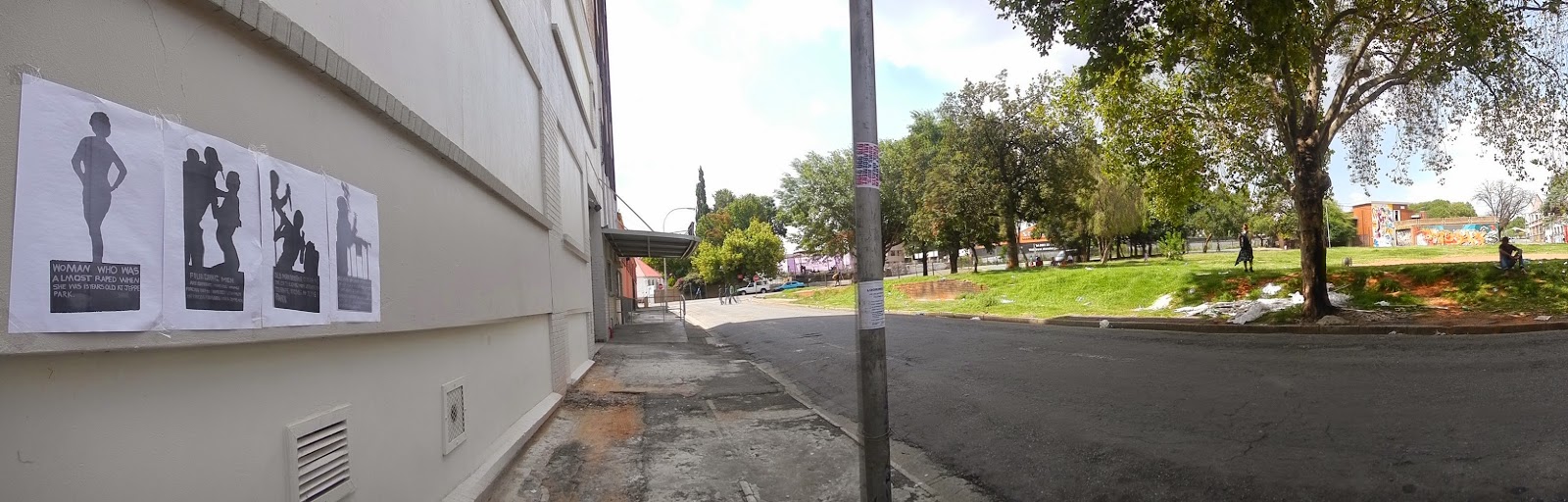
I documented my findings by placing four poster sized images with writing of an event that happened in Jeppestown. These were put up on a wall opposite the park and I observed the way people responded to the installation. Some people walked straight past the pieces; some stopped to take a look but didn’t share any stories with me due to them being fearful of the consequences while others read the posters and told me about other aggressive events that occurred in and around the park as well as in and around the GP hostel down the road.


THE FINAL HOURS

The way I presented my findings were in the form of an art installation and a short film. The art installation documented the people's response to my public installation while the film documented what I experienced in the area in the form of visual and audio clips.

Tow rope representing individuals who disregarded the installation.
Paint drum wrapped with barbed wire and tin can string "telephone" with string cut representing individuals acknowledging the installation but didn't share any stories due to fear.


Paint drum with tin can string "telephone" with string intact representing individuals acknowledging the installation but and who shared their stories.

Final presentation.

The short film that was presented to the group and special guests.

WRAPPING UP

I noticed that the residents and stakeholders reacted the same way to the installation as they did with the actual violence within the area. From my findings the lack of safety within the area doesn’t necessarily need to be amended by introducing more forms of security but rather to create more public spaces in areas where they are absent in order to link the various forms of trade together that are present in Jeppestown as well as to aid in the unification of the community that resides there, thus forming a safer environment for its residents and stakeholders.