Saturday, 11 July 2015

FADA Joint Community Project: Design For and With Local Communities

Three Phase Development Intervention For The Westbury Community


The departments of Architecture, Multimedia Design, Industrial Design and Communication Design visited the Westbury area to investigate the possibility of creating a greater positive impact for their residents. In collaboration with the ongoing local community programmes that are already in existence within the area as well as the students and lecturers at the University of Johannesburg, the project aims to formulate a design intervention through in-depth research that could be brought forward and developed over a five year period.

Please see the following link to the video:
 https://www.youtube.com/watch?v=whe3kMUSQQ8&feature=youtu.be


Concept: Working with the Transformation and Development Centre in Westbury, the group formulated a short, medium and long term strategy to motivate students participating in the existing courses that the centre provides and help lower the unemployment level within the precinct. The short and medium term solution includes campaigns and facilities that would advertise the module and where students would sell their products to generate income as they are learning the set skills. The group focused on the catering program, in particular, with a medium term goal of assembling pop-up stores around Johannesburg to generate income and awareness in order to set up a facility within Westbury, as a long term goal, where the students would run, work and manage the establishment, thus, setting an example within the community residing in Westbury as well as bringing in visitors into the area.

For more information on site mapping and analysis as well as the group's initial ideas on the intervention, please refer to the following link:


MTech Unit 2 Mid Year Portfolio Review

Portfolio Video Review


Students were asked to compile a video of all their projects that they completed in the first and second quarter of the year and explain their main theme that they are engaging in.


Open Building Intensive with Professor Kendall

Open Building Applications For Housing Typologies: 

Mixed-Use Row House


Students were given the task to critically analyze existing living and service spaces through precedent studies of their chosen building typologies and design possible fixed and infill systems within their base building for people to inhabit. Fixed systems included service and staircase shafts as well as door and window openings on the facades of the base building. Infill systems included the interior drywalls and doors within the design.

The concept was to design a mixed-use row house with optimum living and trading spaces for its residents and stakeholders. The design suggests a possible extension space for the ground floor retail program and/or the first and second floor residential spaces.


Sunday, 12 April 2015

Introduction To Studio At Denver

Studio AT Denver

Overview

The Denver area mostly comprises of a light industrial area with a residential sector that is located to the east of Johannesburg CBD and is surrounded by a broader industrial band along its boundary. Main Reef Road is located towards the north of Denver which borders Johannesburg’s historical gold mining belt. Surrounding settlements, such as the Denver Hostels, surfaced within the area during the development of Johannesburg in order to house the migrant workers entering the city. This was also managed by the planning of the infrastructure that was developed during the apartheid era.

Due to the amount of poverty that is evident in KwaZulu-Natal, some of its locals within the province moved to Gauteng in search of job opportunities and a better quality of life.

The community of Denver mostly speak the isiZulu language and follow the conventional hierarchical structure of their decision making within the area. The informal politics within Denver chose that one head chief that makes all the decisions within the community and allocates tasks to his subordinates which then manage the tasks that are given to the residents. This form of hierarchical ranking is part of the Zulu tradition and forms the basis of their culture. Due to this sense of order existing within Denver, it is difficult for the neighbourhood to have complete ownership over their own space and therefore it affects the individual’s form of decision-making. The spatial changes are only made relative to the region’s social structure.

The communal spaces within Denver offer the community a space where they can gather and socialise. These spaces offer the community a sense of ownership and are therefore kept clean. These courtyard areas are the support level in Denver and the settlement buildings around these spaces are adjusted according to what the community needs.

The government promised Denver’s residents that they would be granted suitable housing and when this was not met, they told the community that they would be relocated to areas with affordable housing but none of this was provided. Denver’s inhabitants reside in the ever-growing informal settlements and encounter unhealthy living conditions as their waste is disposed within the main storm water channel. The build-up of waste within this area causes the channel to flood during the rainy season and is seen as a neglected area where there is not sense of ownership. The public toilets are also in poor condition and the drainage channels do not have a decent infrastructure to control the outflow to a designated area. The electrical power lines hang low within these parts which prevents any trucks or waste removal vehicles to enter the area and is also a danger to the residents, especially the children. The quality of the laundry areas, which are by the water points, do not have an adequate drainage system and there are no designated safe areas for the children to play while the mothers wash clothing. These neighbourhood support levels need to be retained in order for the community to have a better quality of life.

Sunday, 29 March 2015

The Future of Open Building

The Future of Open Building

An Explanation Of The Concept

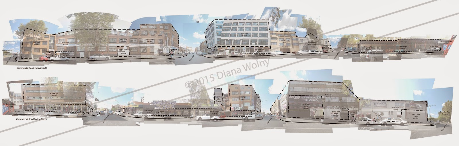
A street analysis of Commercial Street, Fordsburg and redesigning the street edge
with relevance to the Open Building concept. 
© Diana Wolny, 2015
When referring to the notion of Open Building, John Habraken argues that the system should mediate between the needs of the individual as well as the community that inhabit the space. This allows for the design of a building or space with different systems that have the potential to be personalised and altered according to the individual’s or community’s needs at neighbourhood level. These conditions offer a sense of ownership, responsibility and care to those inhabitants, therefore creating an opportunity for a safer and cleaner space for them to occupy.

This is achieved through gathering communication and information, mainly on-site, in order to generate an infrastructure that evaluates what is required for the people within that particular neighbourhood. Through this understanding, one can develop an infrastructure that identifies the urban hardware and urban software within a neighbourhood and how it influences its users. Without the individual, the space would become inflexible and standardised and could therefore have a greater potential of failure due to the fact that the needs of the individual or community could not be met.

The relevance of Open Building is important to the individuals within a neighbourhood as it unites levels of decision making with construction as well as control within the system. These levels include the town fabric (the tissue), the base building (the support), and fit-out (the building’s infill). The buildings and infill within a neighbourhood can be transformed and replaced while the town fabric still remains the same.

This system provides the infrastructure the opportunity to reuse its building parts in order to lengthen its life expectancy and thus prevents the accumulation of waste materials which leads to a better design of an infrastructure. The director of OBOM Research Group, Ype Cuperus, states that Open Building is “a multi-facetted concept, with technical, organizational and financial solutions for a built environment that can adapt to changing needs. It supports user participation, industrialization and restructuring of the building process”.

Sunday, 22 March 2015

Explorations In Urban Design & Architecture Individual Work Assignment

 Explorations In Urban Design & Architecture

Multi-Layered, Mixed Neighbourhoods In Newtown, Johannesburg

Mint Road, Fordsburg
Following our group urban design framework proposal, we were required to choose a site responding to our group analysis. Our design had to respond to the context into which it was inserted as well as relate back to the Open Building concept. It needed to cater for the diverse needs within the area, a selection of occupancy options and affordability levels.

The main intention of Group A's urban design framework was to link Fordsburg Square to Oriental Plaza via Commercial Road and transform it into a fully pedestrianized walkway. This was the site I was going to focus on upgrading for the community of Fordsburg.

The History Of Fordsburg Square & Oriental Plaza

Artist's impression of the events that formed Fordsburg Square and Oriental Plaza  © Diana Wolny 2015
From January until 14 March 1922, there was a strike against the gold miners and their employers due to a wage cut per shift for the black miners and retrenching the higher paid white miners for more affordable black miners. The strike became an open uprising where the South African Army as well as the Air Force were called in to bombard Fordsburg Square. These miners dug out large trenches next to the municipal toilet on Mint Road, a building that sheltered them from the army and would later become a heritage building to commemorate this day. The South African Air Force were informed to bomb the square from above but hit the nearby Presbyterian Church on Mint Road, which is now also a heritage building within the area. This day became known as the Rand Rebellion or Rand Revolt.

Today, Fordsburg Square is one of the main areas of Indian culture in South Africa and is an extremely colourful and lively meeting place for the community as well as its visitors.

Fietas was a flourishing community consisting of the Indian, White, coloured and Malay population before the 1970's. It was made up of two suburbs, being Pageview and Vrededorp, and in the late 1970's most of the community was forcefully relocated to other suburbs during apartheid under the Group Areas Act. While bulldozers broke down existing homes and the resident's belongings were thrown onto the streets, some people of the community stayed within the area in informal settlements while the majority vacated the area to places such as Lenasia and Eldorado park while the Indian traders regrouped in the space now known as Oriental Plaza.

Today Oriental Plaza is a successful tenant-owned shopping mall where people from all over South Africa come and do their shopping mainly over the weekends. The shop owners provide their customers with a unique shopping experience with great deals in what ever they are selling and is definitely the major attraction within Fordsburg.

My Concept

The Intention of my conceptual design was to allow pedestrians to have an enjoyable and exciting journey between two historical landmarks within Fordsburg.


I began analyzing Commercial Road by marking out the active retail edges, hard and dead edges as well as informal seating and street trade activities. I noticed that the street traders along this edge did not have a specially allocated area for them to operate their business and were also open to the natural elements. 
After defining the areas mentioned above, I then began designing a sheltered space for the street traders that also responded to the active retail edges as well as giving the opportunity to create active edges along the hard and dead edges, not only on the ground level but also at the first level of some buildings. 


I noticed that the restaurants and cafeterias along Mint Road and Central Road did not have formal outside seating for their customers and discovered that this was due to the by-laws within those roads. Due to this observation, i wanted to further activate the edges on Commercial Road by adding outdoor spaces for the public to utilize for whatever their needs would be for that time therefore relating back to the Open Building concept.

I allocated areas for outside seating, sheltered street trade and gave the public a green roof to sit on and enjoy the view points towards Oriental Plaza and Fordsburg Square, further linking the two historical landmarks together. A paved area and water fountain area were also added for the public focusing more towards the children occupying the space, giving them areas to play sports as well as a water play area open to the elements.

I also added more trees within this corridor to aid the public in finding their way easier towards each node when approaching the area off Mint Road, Central Road, Lilian Road and High Street. After this exercise, I began cutting away at buildings on the ground and first floors, added volumes above existing one to two-storey buildings and pushing certain building edges out to create an interesting space for the public to move through down this corridor. I opened up part of Fordsburg Square again to commemorate its sole purpose and enhanced the public and green space in that node with the addition of a fountain area in the middle. I moved these traders down Commercial Road to further upgrade the hard and dead edges within the existing road.

I gave the potential for the public to access possible trading spaces on the first floor of certain buildings from the view points in my structure to further deal with the relationship of the lower and higher levels within the corridor.


Final Presentation

Fordsburg mapping analysis with the history behind Fordsburg Square and Oriental Plaza

Street analysis with concept sketches

Plan of potential activities on Commercial Road

Section through portion of Commercial Road, Fordsburg

Cross section through Commercial Road with precedent studies


Saturday, 21 March 2015

Explorations In Urban Design & Architecture Group Work Assignment

 Explorations In Urban Design & Architecture

Multi-Layered, Mixed Neighbourhoods In Newtown, Johannesburg


Overview

The MTech unit went to document information in the Newtown and Fordsburg districts. The class was split into four groups in order to do an in-depth analysis within these four sites and were then asked to compile an urban design framework based on our findings.

As a class, we marked out key nodes within our areas and then discussed how we were going to link them all within our overall urban design framework. 

Overall Urban Design Framework
Overall group presentation
Site model for presentation
After this task, we then moved onto our group urban design frameworks and began altering our areas based on our findings to come up with a development proposal that also responded to our overall scheme. I was part of Group A which focused on Fordsburg and our key nodes were Fordsburg Square and Oriental Plaza.

Mapping of heritage sites as well as analysis of street and building edges

Mapping of types of movement and activities as well as street section analysis through the site
Group A: UDF proposal
New building, green space and parking allocations in Fordsburg

New building allocations above and near existing buildings.
View from Oriental Plaza entrance looking towards Commercial Road